Utilities Surveying
If you need pipes, cables or drainage locating and mapping by a professionally qualified civil engineering surveyor, you are in the right place!
Red Kite Geomatics provides a cost-effective utility mapping service, using survey-grade electro-magnetic detection and ground penetrating radar surveying, along with other complimentary technologies. This non-intrusive, geophysical type survey equipment is used to target buried utilities and infrastructure, and form accurate mapping of pipe and cable positions, depths and routes.
Our utility surveys can assist anyone needing to locate buried services. From a residential property owner looking to find their incoming electricity supply cable, to a large commercial site, where the requirement is to locate, survey and map all underground pipes, cables and drainage and produce a detailed CAD drawing of these assets.
Having a comprehensive and accurate utility survey can enable a project design team to incorporate existing infrastructure into proposed developments and avoid unforeseen conflict with existing utilities, resulting in cost savings by reducing utility relocations, design changes or construction delays; not to mention keeping your workforce safe.
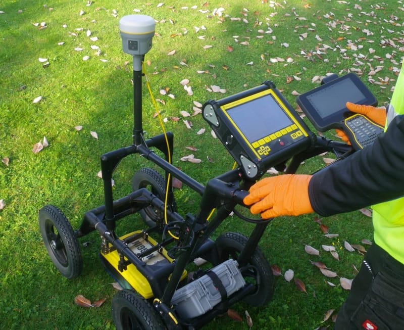
Results are coordinated using robotic total station and RTK GNSS, and are issued as structured and layered CAD drawings, along with associated survey reporting. If required, this information can be combined with existing site surveys or with a base-plan or topographic survey coordinated by us.
Rather than carry out one-size-fits-all type surveys, I recommend an investigative and interpretive methodology, where all aspects of the project objective and site specifics are considered and incorporated into the procedure. This connected approach aims to avoid the cursory, and often incorrect, delineation of signals and reflections that some predetermined and solely grid-based survey specifications may yield.
I take the best from existing survey guidelines such as the RICS, CICES, TSA and PAS 128, and combine this with proven techniques and adaptive methodology, with the aim of achieving accurate, comprehensive and reliable mapping of subsurface apparatus.
Having a comprehensive utility survey prior to excavation is a key component of HSG47 safe digging practices. Accurate and reliable utilities mapping is crucial in reducing the risk of service strikes, keeping your workforce safe and meeting your legal obligations.
Ground Penetrating Radar (GPR)
GPR surveying utilises high frequency radio waves to non-intrusively investigate the subsurface.
Radar pulses are transmitted downward from an antenna that is wheeled on a cart mounted GPR system. The pulses are reflected from boundaries of contrasting dielectric and geo-electrical properties. When these pulses encounter an interface of materials having significantly different properties, a portion of the energy is reflected back to the surface where it is detected by a receiver antenna and either displayed in section for real-time interpretation, or stored as a data-set for post-processing.
GPR is a fantastic instrument, in that it gives us the potential to detect non-metallic utilities and features, as well as those of metallic construction. It is rarely used as a stand-alone technique, rather, it is used alongside electro-magnetic location as part of a robust methodology for utility detection.
As well as detecting reflections directly from utilities, GPR surveys may provide valuable information by revealing features such as such as previously excavated trenches, buried concrete slabs, former foundations, areas of concrete reinforcing, changes of ground composition etc.
Red Kite Geomatics use GPR systems from industry leading manufacturer Sensors & Software to carry out our ground penetrating radar surveys.

Electromagnetic Location
Red Kite Geomatics use electromagnetic location instruments (EML) from best-in-class manufacturer SPX / Radiodetection. This equipment is essentially a sophisticated, high-end type of cable avoidance tool (CAT scan) technology.
These precision locators are used alongside a comprehensive suite of accessories such as active signal transmitters, induction clamps, radio transmitting sondes, flexible trace reels, household electrical supply connectors etc. whereby active signals that are coupled to services can be tracked using the signal locator.
Additionally, this equipment has the potential to detect passive signals that are produced by the alternating current of electrical equipment, and also radio frequency transmissions from broadcasting antenna. Both of these signal types are picked-up, carried, and re-radiated by linear conductors - such as buried metallic utilities.
I passed my course in advanced theoretical and practical instruction techniques to train others in the use of electromagnetic locators in 1995, having used this equipment surveying utilities in the communications sector for a number of years prior to that.

Example combined topographic & utilities survey

My usual area of operation for typical one-day utility surveys is Mid & West Wales - Ceredigion, Carmarthenshire, Pembrokeshire, Powys, Gwynedd, Dyfed, Brecon, Snowdonia and along the M4 corridor through Swansea, Port Talbot, Bridgend and Cardiff.
With larger, multi-day surveys, I am happy to travel further afield and throughout the UK